eBee Classic
The vehicle has an ultra-light shock-absorbent construction and weighs 700g, minimising its impact energy. It features a safety-conscious rear-facing propeller and an autopilot, which manages a range of failsafe behaviours. The eBee can cover up to 12 km2 (4.6 mi2) in a single automated flight, while flights over smaller areas, flown at lower altitudes, can acquire images with a ground sampling distance (GSD) of down to 1.5 cm (0.6 in) per pixel.
Technical Specifications
| Wingspan | 96 |
| Weight (inc. supplied camera & battery) | Approx. 0.69 |
| Motor | |
| Radio link range | 3 |
| Detachable wings | |
| Camera | |
| Cameras (optional | |
| Software | |
| Flight planning & control software (supplied) | |
| Image processing software (optional) | |
| Operation | |
| Automatic 3D flight planning | |
| Cruise speed | 40-90 |
| Wind resistance | 45 |
| Maximum flight time | 50 |
| Maximum coverage (single flight) | 12 |
| Automatic landing | Linear landing with ~ 5 |
| Multi-drone operation | Yes |
| Ground control points (GCPs) | Optional |
| Oblique imagery | 0 to -50 |
Overview
The eBee can cover up to 12 km2 (4.6 mi2) in a single automated flight, while flights over smaller areas, flown at lower altitudes, can acquire images with a ground sampling distance (GSD) of down to 1.5 cm (0.6 in) per pixel.
The eBee enables flight planning and management through it's eMotion software. The user chooses or creates a preferred background map. Then uses this to define the region they want to map. The desired ground resolution is specified (down to 1.5 cm / 0.6 inches per pixel) and the required image overlap is set. eMotion automatically generates a full flight plan, based on GPS waypoints, calculates the eBee’s required altitude and displays its projected trajectory. eMotion offers a confidence-building simulation mode. This virtual flight simulates wind strength and direction, allowing the user to make any flight plan enhancements needed before launch.
The eBee’s eMotion software displays the aircraft’s key flight parameters, its battery level and its image acquisition progress, in real time, while the artificial intelligence inside the eBee Ag’s autopilot continuously analyses onboard IMU and GPS data to control and optimise every aspect of the drone’s flight.
References
Describes the product, specifications, flight planning, operation, mapping, and cameras.
Recommended Specs


Continue Reading
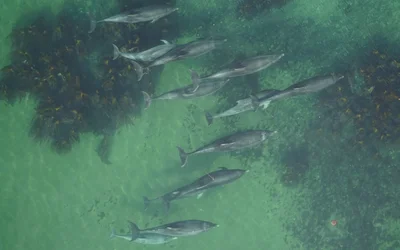
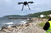
University of Aberdeen has partnered with Duke University to develop a UAV system capable of studying bottlenose dolphins to determine how environmental changes impact the populations

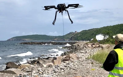
DTU spinout solves mine clearance tasks for the Danish Defence and the offshore wind turbine industry.

3 minutes read
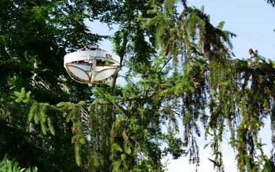
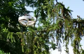
Researchers at ETH Zurich and the Swiss Federal research institute WSL have developed a flying device that can land on tree branches to take samples. This opens up a new dimension for scientists previously reserved for biodiversity researchers.

3 minutes read