How Uncrewed Vehicles are Rising to the Challenge of Natural Disasters
Critical to utilising uncrewed vehicles for disaster relief is the ability to coordinate vehicles into autonomous fleets and leverage live video links for real-time observation.

13 Nov, 2023. 5 minutes read
Natural disasters, such as floods, hurricanes, earthquakes, and wildfires can cause immense damage to human life and property. In recent years, technology has evolved to the point where uncrewed vehicles can be used to help mitigate the effects of disasters. They excel in areas where human access might be limited or hazardous, enabling them to perform critical tasks such as pre-disaster monitoring, post-disaster assessment, debris removal, supply delivery, and environmental data collection.
Critical to utilising uncrewed vehicles for disaster relief is the ability to coordinate vehicles into autonomous fleets and leverage live video links for real-time observation. An example of this is Cloud Ground Control (CGC), a platform that can elevate uncrewed vehicles to be effectively employed in managing and mitigating natural disasters.
Utilising uncrewed vehicles for pre-disaster preparedness
Uncrewed vehicles can be leveraged pre-disaster, such as mapping risk areas and identifying changing environmental conditions as well as post-disaster, for example risk mitigation, rescue and relief.
The foremost strategy to disaster mitigation is pre-disaster preparedness which refers to the monitoring of disaster-prone areas and detecting changes in environmental parameters. These changes help scientists in predicting when a climatic anomaly or disaster may take place and aid in taking preventive actions. Uncrewed vehicles use sensors to gather data in real-time. This data is then sent to software with special algorithms that automatically analyse it and trigger specific actions based on AI interpretation of the results.
CGC, for example, aggregates the data collected from multiple uncrewed vehicles and stores it in a centralised cloud-based platform. This central repository ensures that all relevant data is accessible to decision-makers and experts involved in disaster preparedness.
The sensors gather data across a wide spectrum of phenomena, such as temperature, humidity, atmospheric composition, electromagnetic radiation, and more. For instance, temperature sensors employ thermoelectric materials to convert thermal energy into measurable electrical signals. Electromagnetic sensors exploit interactions between electromagnetic fields and their target materials to discern properties like object proximity, material composition, or radiation intensity.
In the realm of pre-disaster preparedness, the utilisation of uncrewed vehicles equipped with these sensors brings substantial advantages. Firstly, the real-time data collection capability of these sensors enables the continuous monitoring of key environmental parameters that might serve as early indicators of impending disasters.
For instance, sudden shifts in temperature, atmospheric pressure, or gas composition could signify the onset of natural events like wildfires, tsunamis, or seismic activities. By promptly identifying these anomalies, authorities and response teams can be promptly alerted, allowing for timely evacuation and mitigation measures. The robust data security measures offered by platforms like CGC ensure the safeguarding of critical environmental and situational data collected by uncrewed vehicles, enhancing the integrity and effectiveness of pre-disaster preparedness efforts.
Moreover, the automated relay of sensor-derived data to software integrated with specialised algorithms enables swift data analysis, extracting meaningful patterns and anomalies from the collected information. This analytical process aids in identifying potential disaster precursors, assisting experts in making informed decisions and predictions. The subsequent activation of specific actions through AI-driven interpretation further enhances preparedness.
For instance, if a sudden increase in gas concentration indicative of a chemical leak is detected, AI can trigger the deployment of containment measures, thus minimising potential harm to human life and the environment.
Mapping an area post-disaster
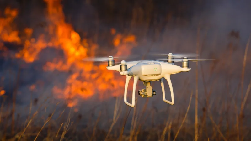
While preparing for natural disasters is key, once they strike, uncrewed vehicles can be on scene rapidly to provide a response. Uncrewed vehicles can be equipped with an array of sensing technologies to accurately map and analyse disaster-stricken areas. These maps are extremely helpful in aiding and increasing the effectiveness of humanitarian efforts. They allow relief workers to identify critical regions and prioritise response efforts. Thermal camera drones can scan a large area and fly over collapsed structures to identify people in distress. Drones can also be employed for pre-and post-disaster large scale 3D mapping of an area which can help in preventive measures before possible disasters and relief efforts afterwards.
Furthermore, uncrewed vehicles contribute to post-disaster mapping, surveying, and assessment. Utilising CGC’s cellular micro-modem CGConnect, uncrewed vehicles can be seamlessly linked to a cloud-based drone fleet management platform, enabling real-time live-streaming, command, and control from a web browser. Instead of having to collect data from multiple drones after they have conducted surveys, CGC allows for a simultaneous data collection and transmission from the entire drone fleet of up to 1000 uncrewed vehicles. This significantly enhances emergency response and disaster relief capabilities.
Humanitarian Relief
Another important use of uncrewed vehicles in disaster relief efforts is their ability to quickly deliver lifesaving supplies. Drones and other unmanned vehicles are currently being employed to directly deliver food, water, and medical supplies to people affected by natural calamities. Due to their maneuverability and flight capability, aerial drones respond much faster in many areas compared to crewed vehicles.
Additionally, uncrewed water vehicles (UWVs) can be used to transport supplies and people across flooded areas. These UWVs are equipped with GPS and obstacle detection systems to navigate submerged streets and obstacles effectively. Using their payload capacity, the UWVs travel through flooded neighborhoods, delivering supplies directly to doorsteps where people are stranded.
Technology plays a huge role in this, for example CGC can serve as a central platform for coordinating the delivery of such lifesaving supplies. It enables real-time tracking of multiple vehicles' locations, routes, and cargo status. Relief teams can monitor the progress of supply deliveries and adjust routes in response to changing conditions or emerging priorities.
An ongoing development
Uncrewed vehicles have the potential to revolutionise the way we respond to natural disasters and save countless lives. By providing critical information and assistance in hazardous environments, uncrewed vehicles are becoming an increasingly important tool in the response to natural disasters. It is important to note, however, that uncrewed vehicles are not a panacea but rather an auxiliary tool in the effort of disaster management. While uncrewed vehicles offer substantial benefits, they complement a comprehensive disaster management approach, underscoring the importance of coordinated relief efforts that integrate emerging technologies like CGC to achieve optimal disaster response outcomes.
References
Qiu,Stephanie. Cloud Ground Control Empowers Emergency Response And Disaster Relief With 5G Drone Fleet Control. 5 April 2023. [Internet]. https://www.advancednavigation.com/news/cloud-ground-control-empowers-emergency-response-and-disaster-relief-with-5g-drone-fleet-control/ .
CORDIS EU Research Results. EU project successfully deploys robots following Italy earthquake [Internet]. https://cordis.europa.eu/article/id/120405-eu-project-successfully-deploys-robots-following-italy-earthquake
Pacific Marine Environmental Laboratory. NOAA Saildrone Hurricane Observation [Internet]. [cited 2023 May 14]. Available from: https://www.pmel.noaa.gov/saildrone-hurricane/
Bateman J. China’s Launching Drones to Fight Back Against Deadly Earthquakes. Wired [Internet]. [cited 2023 May 14]; Available from: https://www.wired.com/2017/01/chinas-launching-drones-fight-back-earthquakes/
Armed with drones, aid workers seek faster response to earthquakes, floods. Reuters [Internet]. 2016 May 16 [cited 2023 May 14]; Available from: https://www.reuters.com/article/us-humanitarian-summit-nepal-drones-idUSKCN0Y7003
Martin G. Drones aid SANDF disaster relief efforts in KwaZulu-Natal [Internet]. defenceWeb. 2022 [cited 2023 May 14]. Available from: https://www.defenceweb.co.za/aerospace/aerospace-aerospace/drones-aid-sandf-disaster-relief-efforts-in-kwazulu-natal/
Science and Technology Directorate. Feature Article: Unmanned Vehicles Could Lead in Dangerous Rescue Situations | Homeland Security [Internet]. 2022 [cited 2023 May 14]. Available from: https://www.dhs.gov/science-and-technology/news/2022/06/09/feature-article-unmanned-vehicles-could-lead-dangerous-rescue-situations
Covid in Scotland: Drones to carry Covid samples. BBC News [Internet]. 2021 Feb 23 [cited 2023 May 14]; Available from: https://www.bbc.com/news/uk-scotland-glasgow-west-56154503
Frey T. Using Drones to Eliminate Future Forest Fires [Internet]. Futurist Speaker. 2018 [cited 2023 May 14]. Available from: https://futuristspeaker.com/technology-trends/using-drones-to-eliminate-future-forest-fires/
Partheepan S, Sanati F, Hassan J. Autonomous Unmanned Aerial Vehicles in Bushfire Management: Challenges and Opportunities. Drones. 2023 Jan;7(1):47.
Drone Amplified. Fire Management System Embedded to Drones [Internet]. Ignis by Drone Amplified. [cited 2023 May 14]. Available from: https://droneamplified.com/ignis/
Ocean Infinity. Our Technology - Ocean Infinity [Internet]. Ocean Infinity. 2022 [cited 2023 May 14]. Available from: https://oceaninfinity.com/ourtechnology/
Tabor A. Volcano-observing Drone Flights Open Door to Routine Hazard Monitoring [Internet]. NASA. 2022 [cited 2023 May 14]. Available from: http://www.nasa.gov/feature/ames/volcano-observing-drone-flights-open-door-to-routine-hazard-monitoring
Bonali FL, Tibaldi A, Marchese F, Fallati L, Russo E, Corselli C, et al. UAV-based surveying in volcano-tectonics: An example from the Iceland rift. Journal of Structural Geology. 2019 Apr;121:46–64.
eBee X mapping drone - Drones [Internet]. AgEagle Aerial Systems Inc. [cited 2023 May 14]. Available from: https://ageagle.com/drones/ebee-x/