Fixing Positioning: Why GNSS Alone Fails Utility Robots — And How Sensor Fusion Bridges the Gap
Utility robots can't always count on GNSS, especially in dynamic, busy environments like cities or industrial settings. By combining data from multiple sensors, Fixposition shows how sensor fusion can help robots stay on track and work reliably in the real world.

18 Jun, 2025. 5 minutes read

Introduction
The demand for robotics in utility sectors, ranging from infrastructure inspection to port logistics, is growing quickly as industries seek to automate labor-intensive and hazardous tasks. Reliable and precise navigation is a must for these robots, especially those that operate in cluttered, dynamic environments where there are obstacles, moving vehicles, and complex layouts. However, Global Navigation Satellite Systems (GNSS) alone is often insufficient for this type of complex navigation due to signal loss in urban canyons, near power lines, or indoors.
Some robotic navigation systems rely on detailed 3D maps built in advance using techniques like SLAM (Simultaneous Localization and Mapping). While powerful in theory, these solutions also face major limitations in real-world large-scale applications because environments change constantly and maps quickly become obsolete. Additionally, these methods often require high-end LiDAR sensors and GPU-intensive processing, which increases costs and complexity, making it difficult to scale across large fleets.
Fixposition, a Zurich-based company, is at the forefront of solving this challenge with high-precision global positioning solutions for autonomous machines. Rather than relying solely on GNSS or pre-built maps, Fixposition combines multiple sensor modalities: GNSS, computer vision, inertial sensors, and, optionally, vehicle data, into a unified solution. Its Vision-RTK 2 sensor demonstrates how intelligent sensor fusion effectively enables real-time localization in complex environments.This article explores the core navigation challenges for utility robotics and how Fixposition’s sensor fusion technology offers a scalable, adaptable, and cost-effective alternative to traditional approaches.
Challenges Utility Robots Face in Complex Environments
Before diving into the solution, it’s important to understand the problem. Utility robots face unpredictable terrain, both physical and electromagnetic. Their success depends on precise navigation in areas where GNSS falls short, and where adaptability and scalability are key to deployment at scale.
GNSS Limitations
Utility robots often operate in environments where GNSS signals are unreliable. Tall buildings, bridges, dense foliage, and power infrastructure can block or reflect satellite signals, which can lead to signal loss or degradation. Multipath interference, where signals bounce off surfaces before reaching the receiver, is especially problematic in urban and industrial settings, and causes significant positioning errors.
Demand for Versatility and Scalability
Modern utility robots are expected to perform across many different environments, from city streets, to orchards, and mines. This versatility requires navigation solutions that can adapt to different conditions and robot types. Scalability is also important, as organizations look to deploy fleets of robots for diverse applications without the need for excessive customization or integration overhead.
Cost and Integration
Traditional high-precision positioning systems, such as RTK/INS (Real-Time Kinematic / Inertial Navigation Systems) are often prohibitively expensive and require complex integration and software customization. These factors contribute to high development costs and lengthy time-to-market, which can hinder the adoption of robotics in utility sectors.
Fixposition’s GNSS-Vision Fusion Technology
Rather than filling the gaps left by GNSS, Fixposition’s approach changes how robotic systems can achieve reliable navigation in complex environments. The company’s sensor fusion engine combines GNSS, camera-based vision, inertial measurements, and optional vehicle kinematics, which enables consistent, real-time localization, even when satellite signals are intermittent or unavailable. This approach removes the need for pre-mapped environments and highly customized deployments, providing greater flexibility and reduced operational overhead.
How It Works
Fixposition’s deep sensor fusion engine, called xFusion, is at the center of the solution. This software component blends inputs from GNSS, vision (camera), inertial measurement units (IMUs), and vehicle data for centimeter-level accuracy. In GNSS-denied zones, like tunnels, dense foliage, or reflective surfaces, Fixposition’s visual-inertial odometry maintains a low drift rate (less than 0.75%), which enables continuous positioning in dynamic environments.
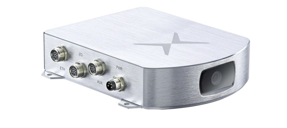
Fixposition’s Vision-RTK 2 sensor demonstrates this approach. It delivers real-time, globally-referenced position with RTK-level accuracy (1 cm + 1 ppm), in a form factor that is compact, lightweight, IP66-rated, and suitable for outdoor and industrial environments. This system is designed for ease of integration with common robotics platforms through interfaces like ROS, PX4, CAN, and UART.
Key Advantages
Affordability: Using advanced sensor fusion, Fixposition offers performance comparable to high-end RTK/INS systems, while significantly reducing hardware and integration costs. The company’s pre-built, cost-effective solutions help robotics engineers reduce development and integration expenses.
Fast Integration: Vision-RTK 2 is designed for quick testing and deployment. It is compatible with common robotics middleware (ROS, PX4) and standard interfaces (CAN, UART), meaning that time to integration and deployment is minimized. The modular design allows for adaptation to various sensors and robot platforms, including drones, ground robots, and industrial vehicles.
Scalability: Fixposition’s solutions are tailored for different customer needs and operational environments, from urban to rural, industrial to agricultural. The hardware is forward-looking, and continuous software updates ensure that equipment provides long-term value and adaptability as requirements change.
Accelerated Time-to-Market: Time-to market and technical risk for robotics teams are reduced with Fixposition’s ready-made solutions, expert support, and evaluation/demo platforms.
Real-World Use Cases in Utility Operations
Fixposition’s positioning solutions are field-proven in some of the most demanding operational environments. Here are a few examples of how utility robots leverage deep sensor fusion for consistent, real-time localization:
Citywide Street Sweeping: Reduced Downtime by 90%
A customer has deployed over 500 autonomous street-sweeping robots across a major metropolitan area, including downtown cores with high-rise buildings. With Fixposition’s positioning engine, robots transitioned seamlessly between GNSS-available and GNSS-denied areas. Navigation-related manual interventions dropped by 90%, dramatically improving operational uptime.
Fully Automated Port Logistics: +40% Productivity
In a major shipping port, a customer integrated Fixposition’s Vision-RTK 2 to enable autonomous truck navigation among dense metal containers and under bridges. Without relying on pre-built maps, the vehicle maintained consistent performance. This resulted in a 40% increase in productivity and helped address labor shortages.
Expanding Security Patrol Coverage – 4x Customer Growth
A provider of security robots expanded their reach into underground and dense urban facilities using Fixposition’s technology. Over the following year, the company quadrupled its customer base and improved teleoperation efficiency from one operator per four robots to one per twenty.
Adaptability
Each deployment is optimized for the specific environment and robot form factor, maintaining robust performance whether on the ground, in the air, or in industrial settings.
Integration and Evaluation
Fixposition takes a collaborative approach to integration and works closely with customers to define requirements, select the optimal sensor stack, and design the system architecture In addition to hardware like the Vision-RTK 2, Fixposition offers software integration and customization services to meet specific operational goals..
Evaluation typically starts with onsite demonstrations, including installation, data collection, and calibration. The data is then benchmarked against ground truth, with post-demo analysis providing actionable insights for further optimization. Fixposition’s flexible integration software architecture supports integration with existing sensor payloads and perception stacks, keeping disruption minimal while accelerating deployment.
Conclusion: Enabling Scalable, Reliable Utility Robotics
Fixposition’s GNSS-vision fusion technology addresses the core challenges of utility robotics: delivering navigation accuracy, robust operation in GNSS-challenged environments, and cost-effective, rapid integration. Its combination of tightly integrated hardware, adaptive algorithms, and software customization positions it as a strong partner for developers building the next generation of autonomous systems. As industries push for safer, more efficient robotics, robust positioning technology like Fixposition’s will continue to play a pivotal role.
For more information about Fixposition’s solutions, visit www.fixposition.com.